Welcome to my Map Analysis Catalog for GIS3015 at Florida State University. I collected my data mainly using Google and exploring many different websites that Google found for me. I also used some of my own images (such as doppler radar, and the like) I have collected through the years of me being a weather dork (haha). I hope you enjoy my collection of maps and photographs :)
Enjoy!
Cristina Mazza
Friday, August 1, 2008
Standardized Choropleth Map
 This is a standardized (according to area and population of the state) choropleth map of the population density of the United States. The New England area seems to have the highest population density, and the mid-western states have the least population density.
http://commons.wikimedia.org/wiki/Image:USA_states_population_density_map.PNG
Nominal Area Choropleth Map

This is my nominal area choropleth map of the Election procdes of this year. The data represented can not be ordered in any way, but the contry is clearly divided. The Democrats, at this time, seem to be winning.
http://politicalmaps.org/wp-content/uploads/2007/12/2008-prediction-map-11252007.jpg
http://politicalmaps.org/wp-content/uploads/2007/12/2008-prediction-map-11252007.jpg
Tuesday, July 1, 2008
Index Value Plot
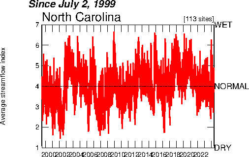
This is an index value plot of the streamflow in North Carolina. It shows whether the streamflow was above average (wet), average, or dry from 1999-2008.
Classed Choropleth Map

This is a normal classed choropleth map. It shows the amount of males per 100 females inthe United States. Nevada looks to have the most males per females. The East seems to have less males per females than the west does.
Unclassed Choropleth Map
 This is a Flash Density map of the United States. It shows the amount of lightning flashes per square km per year. Florida proves tobe the lightning capital of the world.
Bivariate Choropleth Map
 This is a bivariate choropleth map comparing population density and population change in Russia. It seems that the higher population density had the higher population change.
http://www.geog.le.ac.uk/russianheartland/DemographicMaps/images/PopulationMaps/RaionMaps/7RaionPopDenPerCh8902.jpg
Subscribe to:
Posts (Atom)
